Midland Ganaraska Hiking Trail Club president, Marc Vallee has decided to step down as president of the Midland club, after having held this position for almost 30 years. The Ganaraska Hiking Trail Association (GHTA), as well as the Midland club, appreciate his dedicated leadership and enthusiasm for hiking over so many years, while growing the Midland club and maintaining the Midland and Tiny sections of the Ganaraska Hiking Trail in good shape. Marc also attended GHTA board meetings twice a year, and his attendance record and input at these meetings were impeccable.

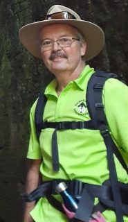
We are fortunate to advise that Marc will be succeeded by Larry Piitz, who some of you may know from the many hikes he has led. Larry is also the Midland club’s Trail Director for the last couple of years. Larry has leadership experience as he is currently also president of the North Simcoe Anglers and Hunters Conservation Club.
Let’s applaud Larry for stepping up to the plate, and provide him with the support he needs to continue in Marc’s footsteps, and lead a vibrant and growing Midland Ganaraska Hiking Trail club.
Frieda Baldwin, President,
Ganaraska Hiking Trail Association, Inc.