Chisholm Trail, the road between the community of Sadowa and Black River Road, is closed until December 11 for bridge work. The Chisholm Trail road section is the western end of the Wilderness Club trail. Hikers should avoid this area until we have notification that the work has been completed.
Author: John Sloan
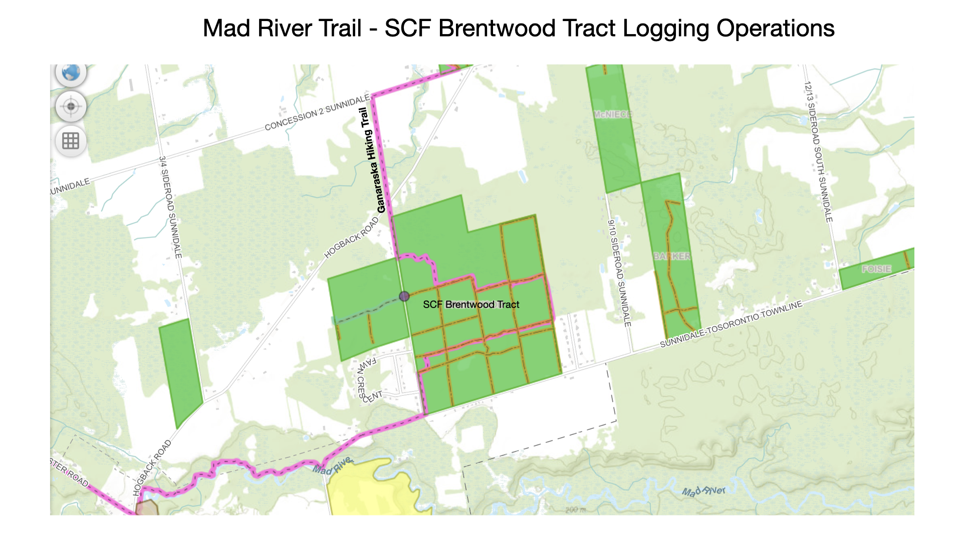
2026.06.20 – Mad River Trail Affected by Logging Operations in SCF Brentwood Tract
Please note that on Tuesday, June 23 harvest operations will begin in SCF Brentwood Tract. Signs will be posted on Tuesday morning. The eastern half of Brentwood will be closed for the duration of the operation, approximately 2-4 weeks. The wood will be coming out 6000 Sunnidale-Tosorontio Townline.
The Ganaraska Mad River trail goes through the Brentwood Tract and will be affected by this logging operation. Please avoid this area while logging is active and obey all signage in the area.
An update will be provided when we are told the logging operation is complete.
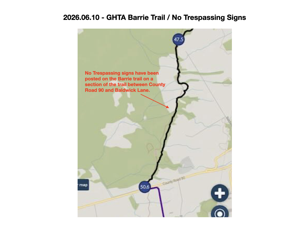
2026.06.10 – Barrie Trail Affected by No Trespassing Signs
A new landowner has posted No Trespassing on the Barrie trail about 1.5 km north of where the Barrie and Mad River trails meet at County Road 90. The Barrie Club leadership is trying to contact the landowner to clarify if this means all use is prohibited or would hiking be allowed and ATV traffic prohibited (there has been a lot in this area). Until the landowners intentions are fully understood we advise avoiding the area and hiking on some other stretch of our 500 km trail.
The attached Ondago screen shot shows the approximate location of the No Trespassing signs.
2026.04.30 – Barrie Collingwood Railway (BCRY) Active Transportation Trail Opened
The Mad River leadership team is pleased to announce that the official opening of the Simcoe’s Barrie-Collingwood Railway (BCRY) Active Transportation Trail between Stayner and Angus took place on April 30th, 2026. There is no longer any restriction on using this multi-use trail that forms part of the Mad River trail section. Hikers are encouraged to exercise caution at intersecting roads and obey all posted trail signage. Please stay alert for cyclists coming from behind you; be courteous and leave enough room for them to pass.
From the Simcoe County website announcement – “The full extension, spanning approximately 23 kilometres along the former Barrie Collingwood Railway corridor, has been transformed into a multi-use active transportation trail connecting the communities of Collingwood, Stayner, New Lowell and Angus, while passing through several other small villages and towns along the way. With this expansion, the Rail Trail now extends nearly 34 kilometres from Collingwood to Angus. The trail provides residents and visitors with a safe, accessible route for walking, cycling and other non-motorized uses, while preserving a historic transportation corridor.”
Completing this section of the Mad River trail is now necessary for end-to-end badge recognition (it had previously been excluded due to the trail conditions).
Please check out this newly transformed section of the Mad River trail in the near future.
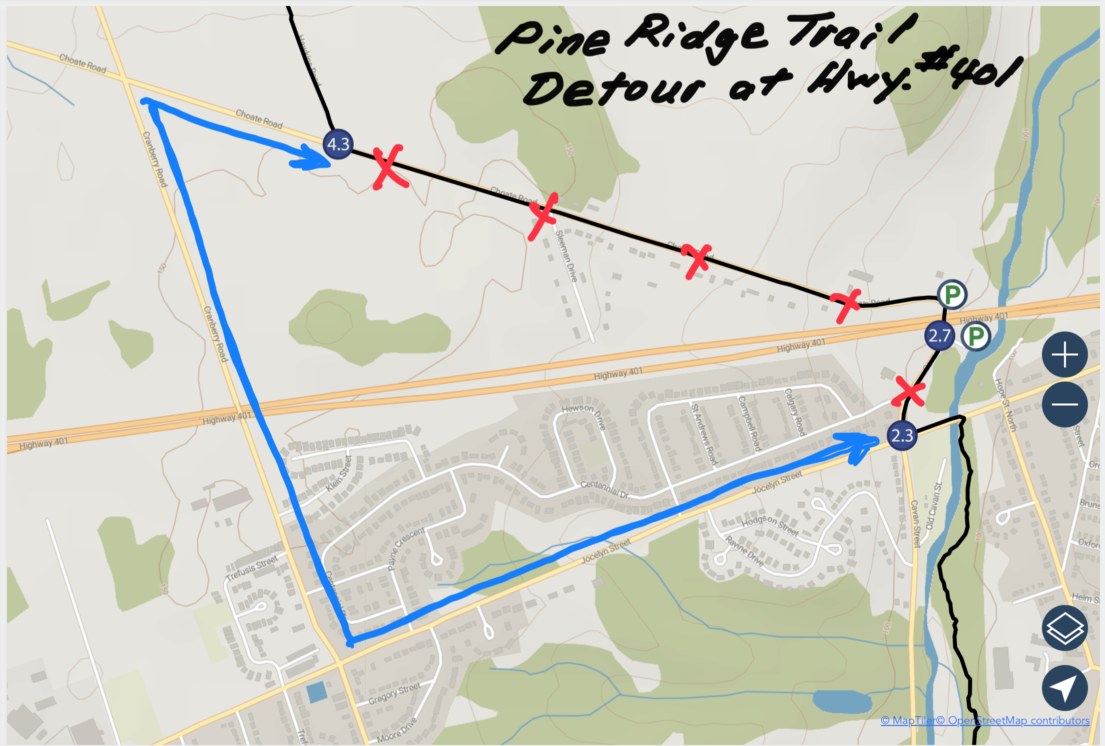
2026.05.22 – Pine Ridge Trail Detour at Hwy #401 Affecting Trail For Longer Time Than First Expected
A NEWS post on August 8, 2025 described a detour on the Pine Ridge trail at Hwy #401 that was expected to last a few months. The detour is where Choate Road crosses under Hw #401 (km 2.7 on Map 1 of the Trail Guide Map series). It appears now that the detour will be in place for a much longer time than originally expected. A reminder of the description of the reroute follows and a map has been included to help explain the reroute.
Hikers travelling north must now proceed straight at the Jocelyn St. /Cavan Rd. intersection (km 2.3) to Victoria St. N. (approximately 1.0 km). Turn right (north) at Victoria St. for 1.5 km to the intersection with Choate Rd. Turn right on Choate Rd. for 0.5 km to the intersection with the unmaintained section of Hawkins Rd.(km 4.3) where you will rejoin the GHT.
Hikers travelling south must turn right (west) at the Hawkins Rd./Choate Rd. intersection (km 4.3) to the Choate Rd. / Cranberry Rd. intersection (0.5 km). Turn left on Cranberry Rd. and travel south to the intersection with Jocelyn Rd. (approximately 1.5 km). Take a left on Jocelyn St. to the intersection where the GHT meets Molson St. (approximately 1.0 km). Turn right (south).
Midland Club – Trail Sharing Announcement
For many years, the Ganaraska Hiking Trail Association has benefited from a property use permit for the Georgian Bay Snowriders (GBSR) trail between just west of Newton Road to Hole in the Wall (Hwy #12). Hikers are hereby notified that the Baxter ATV club now also has a property use permit with the GBSR for the trail between Reeves Road and hwy 400. Hikers should therefore expect and respect the presence of ATV’s on that trail.
We thank the GBSR club for their ongoing support for our Midland hiking club, such as letting us use their parking lot and some of their tools. We can also use their meeting room if needed. Thank you Georgian Bay Snowriders! https://snowriders.ca/
Spring Hunting in Simcoe County Forest
We have been advised by the local Ontario Federation of Anglers and Hunters about the spring hunting season in Simcoe County Forest.
Wild Turkey – Open Season – April 25, 2026 to May 31, 2026 inclusive.
Black Bear – Open Season – May 01, 2026 to June 15, 2026 Inclusive.
The Ganaraska Hiking Trail goes through 23 different Simcoe County Forest tracts, and hunting is allowed in 18 of the 23. The tracts where hunting is not allowed are Charlebois, Martin’s Valley, Miller, Museum and Thompson. In all other tracts please be sure to wear bright colour clothing / hats / vests / etc. if hiking during the time periods mentioned above.
Our thanks to the OFAH for this information.
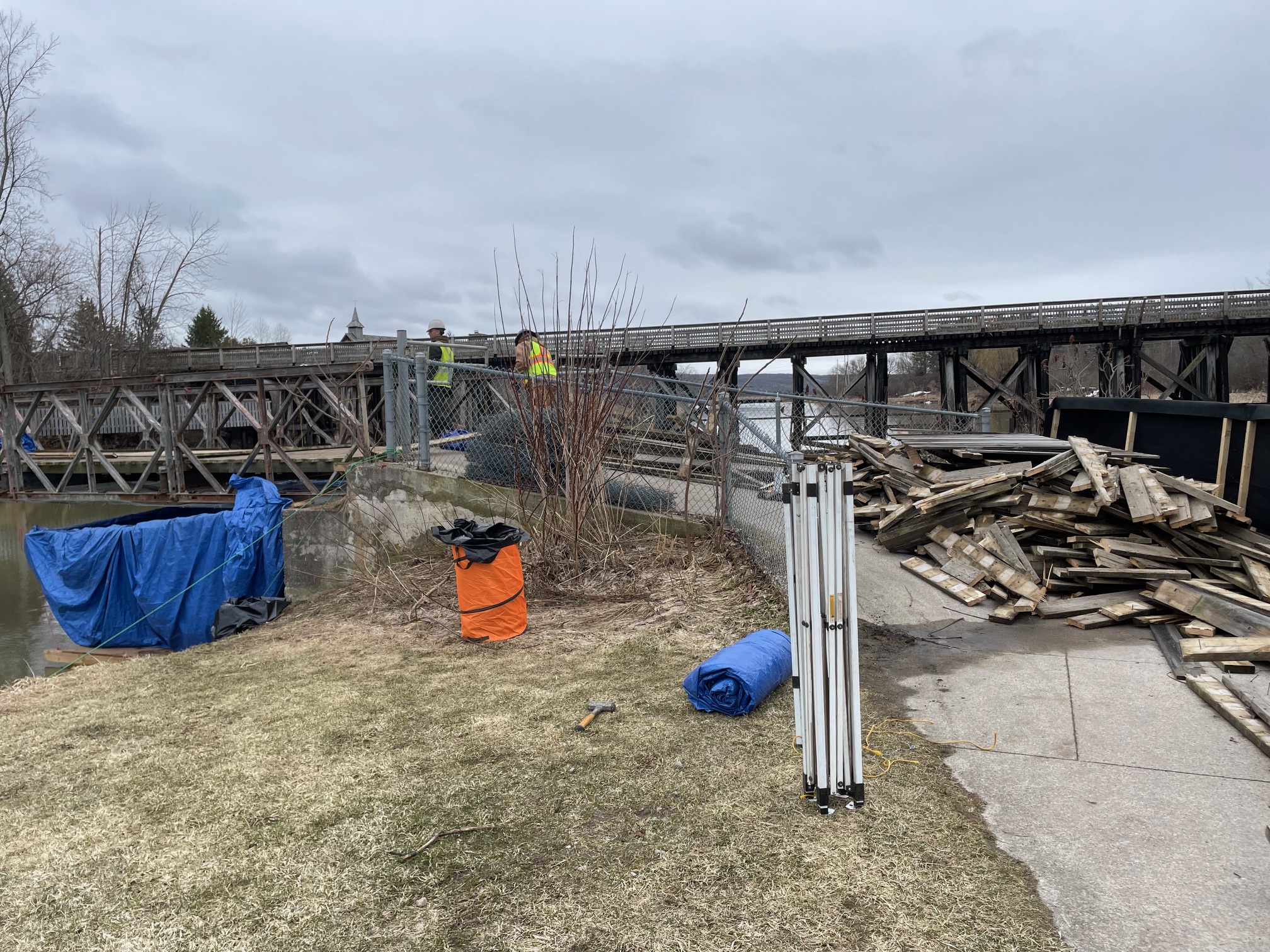
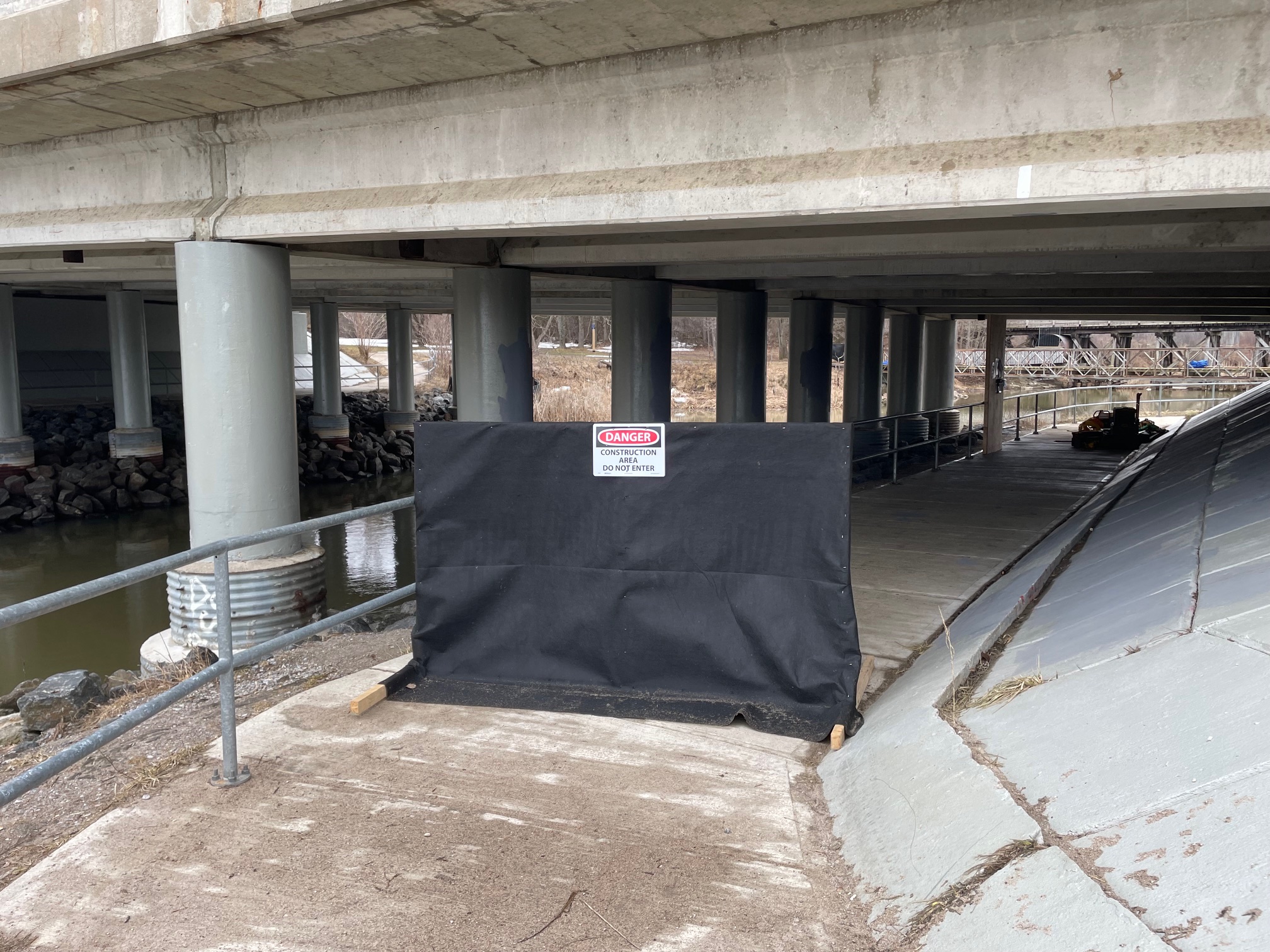
2026.04.06 – Midland Trail Detour Around Closed Bridge at Wye River
2026.05.21 Update – Work is completed. Trail and bridge now open for use.
A detour has been created to get around the Wye River bridge closure affecting the Midland trail. In the attached picture the green route is the detour and the red route indicates the section of the normal trail that is affected by the bridge closure. A description of the detour follows.
“At km 13.6 of the Midland section, note that the small pedestrian bridge that leads the trail under highway 12 to Sainte Marie Park is under construction and closed until the end of May. Therefore, as a detour, continue on the paved Tay Shore Trail across the wooden tresle bridge, which leads to the green highway 12 bridge. Stay on the paved trail until it turns right (east). At the next intersection turn left (north) immediately past the creek railings, enter the forest through a small opening from where you will pick up the existing Ganaraska Hiking Trail blazes again.”
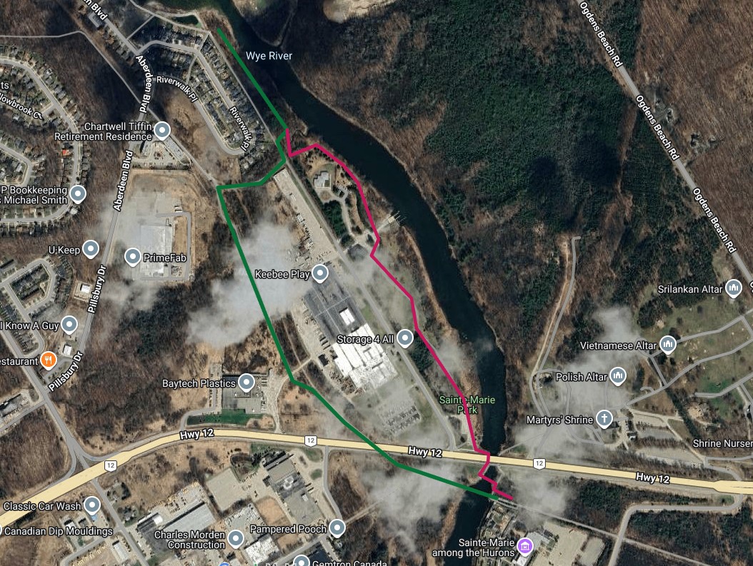
2026.04.04 – Bridge Construction Affects Midland Trail
The pedestrian bridge over the Wye River in Midland is closed for construction until end of May (W3W = contracting.sprees.segment / coordinates = 44.73554, -79.84553). A reroute will be posted in the next few days.
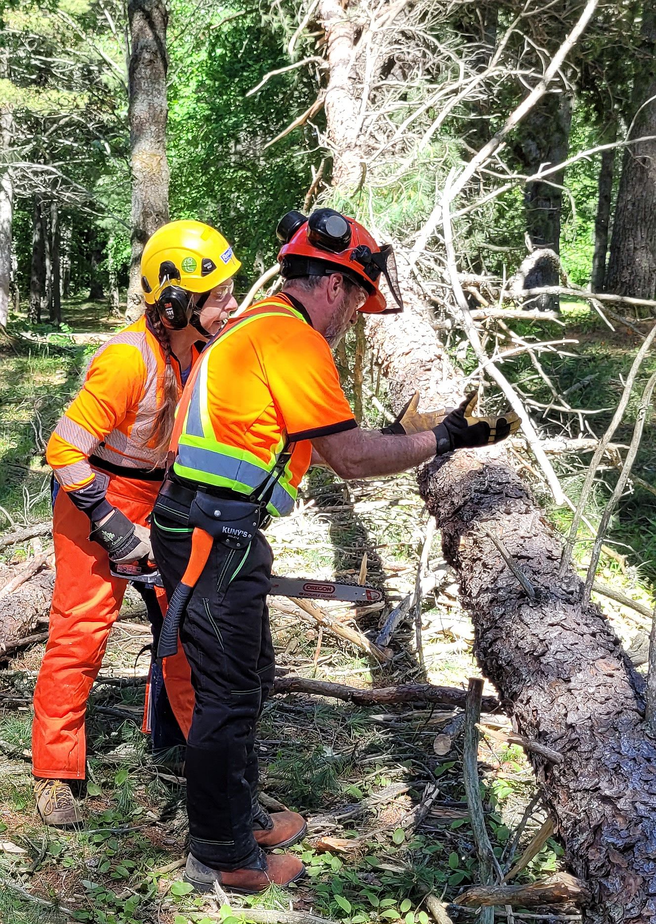
Chain Saw Course – May 2 & 3, 2026
The Ganaraska Hiking Trail Association Inc (GHTA) is pleased to announce that in partnership with Hike Ontario, a 1 day chainsaw course for GHTA members is being offered on May 2 and May 3, 2026, at a Midland GHTA club member’s property near Midland, Ontario. The course is being delivered by Bernie Stockermans of Logging & Sawmill Safety, who last year provided this same course to some GHTA volunteers, when the County of Simcoe Forestry hosted the course in Midhurst.
The course will consist of an indoor session in the morning to discuss safety, chainsaw maintenance, etc. and the afternoon session will be a field practice and observation session. Course participants will have to bring a chainsaw, as well as proper safety equipment such as chaps, helmet, ear protection, safety glasses. Chaps that tie around the leg are recommended. Some of our clubs have bought this PPE safety equipment last fall and club members should be able to borrow it.
The course fee will be $150 + HST. Details about how to register will follow in the next few days.
Any Ganaraska Hiking Trail member who participates in the course, will be reimbursed 50% of the course fee immediately upon completion of the course, and the other 50% after contributing to at least one work party as a chainsawer.
For more information, contact president@ghta.ca or call Frieda Baldwin 705-245-1005. The Hike Ontario announcement for the course can be seen at https://hikeontario.com/chainsaw-course-may-2026/ .