Oro-Medonte Club off-road trail between Peter Street and Vasey Road now blazed and available
2013 Guide Book, Map 19 (Change 11 June 2020)
2019 turned out to be a very wet spring, and caused the northern part of the Oro Medonte section of the Ganaraska Hiking Trail to be closed due to flooding, and the trail was moved to roadside walking between Peter Street and Vasey Road on Line 5N. This past spring has been a lot drier and has allowed us to re-open the off-road section between Peter Street and Vasey Road, and trail maintenance has been done so that that section is now open again.
Please note that currently that our Ondago mapping app still shows the detour along Oro-Medonte Line 5, but the app is currently being updated, and should show the corrected route shortly.

Change Announcement for Wasaga Beach Trail (Map 27 of 2013 GHTA Guidebook)
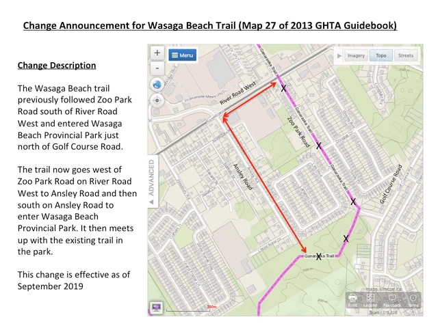
Trail Change, Wasaga Beach Map 26
Wasaga Beach September 2019 Map 26

This change reroutes the trail off busy Country Road 7 and Centre Line Road to pass through a forest trail on the west side of Stayner’s new EcoPark, on through Station Park, and then along the footpath beside the abandoned CN Railway tracks.
TRAIL CHANGE ORILLIA SECTION (MAP 18)
There has been a loss of permission to use a section of the Orillia Club’s trail, specifically the western half of the trail running between the 10thand 9thlines of Oro-Medonte. We are working on a solution, but hikers are to proceed no further west along that section than the posted “No Trespassing”sign. Likewise do not use the section from Line 9 N going east (it is also posted “No Trespassing”). See the revised Map 18 with cross hatches on the closed section.Ganaraska-Trail-Map-18-showing-closed-section-V2-1Download
Barrie Club trail reroute at east end (Barrie / Orillia junction)
A new trail has been established to eliminate some road walking at the east end of the Barrie trail starting at Line 6N in Oro-Medonte (reference map #19 of the GHTA Guidebook). The new trail follows established bike trails between Line 6N and Line 5N through the Crawford and Tustin tracts of Simcoe County Forest. Our use of these trails is done with the approval and support of the Simcoe County Mountain Bike Club (SCMBC) and we appreciate their willingness to share the trail. The new starting point for the trail can be found by driving to the end of the paved portion of Line 6N running south from Horseshoe Valley Road and walking 250 metres south along the existing trail into the forest. This stretch is still part of the Orillia trail and is now blazed blue as a side trail to the new junction of the Orillia and Barrie Trails. Please remember when using the new trail that bikers will have the right of way (as always). The new trail is blazed and ready to use.
There are three map files attached for reference. One is an updated version of map #19 from the Guidebook. The other two are GPS plots of the trail – one on a topo map and one on a satellite image of the area.
GHTA Guidebook Map 19 as of 20190506
Detailed map of Sugarbush Estates Bypass

Wasaga Beach
Tiny section closure at western end – December 2018 – GHTA Map 28
Please be advised that the western end of the Tiny section of the Ganaraska Hiking Trail is currently closed from just west of Crossland Road to Archer Road.
Archer Road is the northern most street on the Wasaga Beach section. A landowner is no longer allowing us permission to use his property, so we are currently looking (and may have found) a reroute that may open later this year.
In the mean time, going east from Archer Road on the Tiny section of the Ganaraska is impossible. So your best option is to pick up the trail again from about 1 km west of Crossland Road on the Tiny Townline. You will see that the road dead ends at a farm. A forest track continues, but that leads to the closed section. Park near the farm on the side of the road and hike east towards the Tiny Marsh along the Townline until further notice.
Pine Ridge – November 2018 – GHTA Maps 1, 2, 3
Barrie – February 2018 – GHTA Map21, SCF Museum Tract Reroute
Wasaga Beach- April 2010 Map 26 Map 27 Page 35 Page 36-37
Wilderness – May 12, 2018 – Ragged Rapids Loop Trail 500m re-route, approx. 1.5 km from Victoria Bridge. Notice that part of the trail crosses over private property, as is the case in a number of locations. Please respect private property.
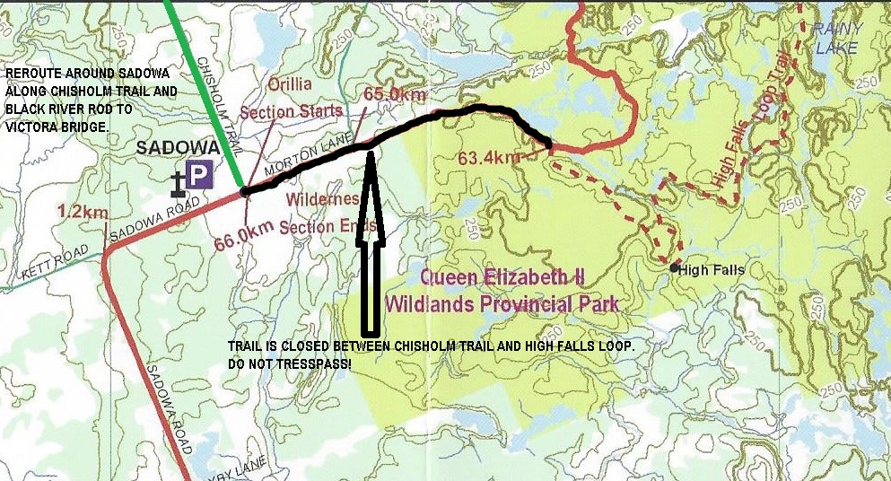
– May 2015 – The Sadowa entrance to the Wilderness Section is closed. This means no entrance or exit at this access point. Hikers are required to walk on Chisholm Trail and the Black River Road to re-route around the Sadowa access point. The High Falls Loop Trail can be access via Victoria Bridge and would require an overnight stay to complete the loop. Please respect private property and do not trespass.
The GHTA Wilderness Club is currently working with QEIIWPP to develop a workaround. Will keep everyone posted as this progresses.